Southern Ethiopia Road Trip: Tribes, Tribes, and Natural Wonders
Southern Ethiopia offers one of the most diverse and culturally rich travel experiences in Africa. This vast region stretches from the capital Addis Ababa down to the Kenyan border, encompassing dramatic landscapes, ancient archaeological sites, pristine lakes, and some of the continent's most fascinating indigenous communities. An 8-day road trip through this remarkable region provides an unforgettable journey through time, culture, and natural beauty.
Unlike the well-trodden historical circuit of northern Ethiopia with its rock-hewn churches and medieval castles, the south remains relatively unexplored by mass tourism. This means more authentic experiences, fewer crowds, and the opportunity to witness traditional ways of life that have remained largely unchanged for centuries.
Overview of the Journey
The southern Ethiopia road trip covers approximately 1,500 kilometers of diverse terrain, from highland plateaus to lowland savannas. The journey takes you through:
- Ancient megalithic sites dating back nearly a millennium
- Rift Valley lakes teeming with wildlife
- Traditional tribal villages with unique architectural styles
- National parks and protected areas
- Remote communities maintaining centuries-old customs
- Varied landscapes from lush green highlands to arid lowlands
The trip requires a good vehicle and experienced driver, as road conditions vary significantly. Some routes are well-paved highways, while others are rough dirt roads that wind through challenging terrain. The infrastructure improves each year, but patience and flexibility remain essential virtues for travelers in this region.
Day 1: Addis Ababa to Arba Minch
Departing the Capital
Your Southern Ethiopia adventure begins in Addis Ababa, the country's bustling capital situated at 2,400 meters above sea level. An early morning departure is essential to avoid the capital's notorious traffic and maximize your daylight hours on the road.
As you leave the city behind, the landscape quickly transforms from urban sprawl to rural countryside. The road south is one of Ethiopia's main arteries, connecting the capital to the country's southern regions and beyond to Kenya.
Tiya: The Standing Stones
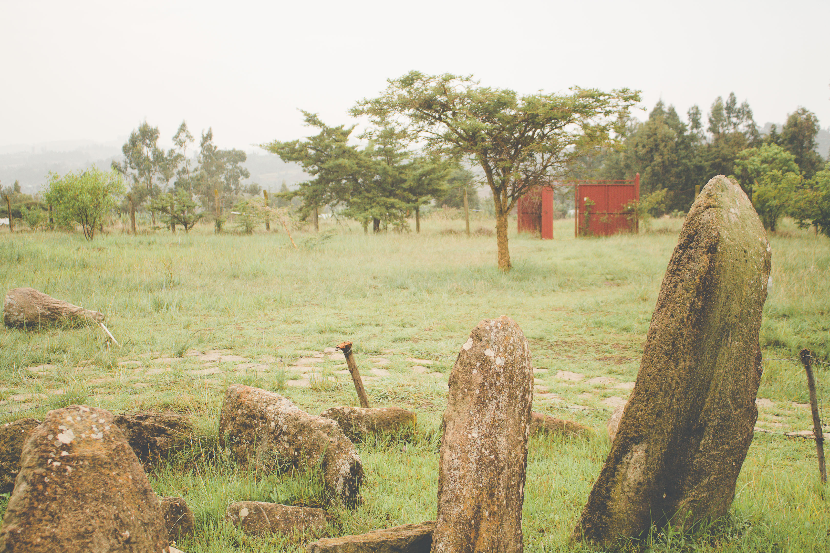
Your first major stop is the village of Tiya, approximately 80 kilometers south of Addis Ababa. Here lies one of Ethiopia's lesser-known but fascinating UNESCO World Heritage Sites: the Tiya Megalithic Stelae.
The site contains 36 standing stones, part of a larger field of approximately 160 megaliths scattered across the area. These carved stelae date back to the 12th century and serve as grave markers for a warrior community that once inhabited this region.
What makes Tiya particularly intriguing are the engravings on the stones. Each stele bears symbolic carvings that tell us something about the person buried beneath:
- Sword symbols indicate the number of enemies the warrior had killed in battle
- Circular and geometric patterns may represent shields or other military equipment
- Human figures sometimes appear, though their exact meaning remains debated
- Jewelry depictions suggest the burial site of a notable woman
The site is thought to represent an ancient pagan culture that predated Christianity's arrival in this part of Ethiopia. Standing among these weathered stones, with their mysterious engravings and 900-year history, provides a powerful connection to Ethiopia's pre-Christian past.
The Journey South
After Tiya, the road continues south through agricultural landscapes dotted with traditional round tukul houses. The countryside is alive with activity—herds of cattle and goats being driven along the roadside, donkeys pulling carts loaded with goods bound for market, and farmers tending their fields of teff (the grain used to make injera, Ethiopia's staple bread).
The "false banana" trees (enset) become increasingly common as you travel south. These plants resemble banana trees but produce no edible fruit. Instead, the roots and stems are processed to create a starchy food called kocho, which is a dietary staple in southern Ethiopia.
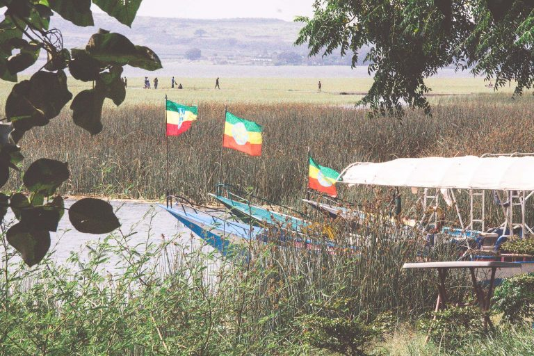
Arriving in Arba Minch
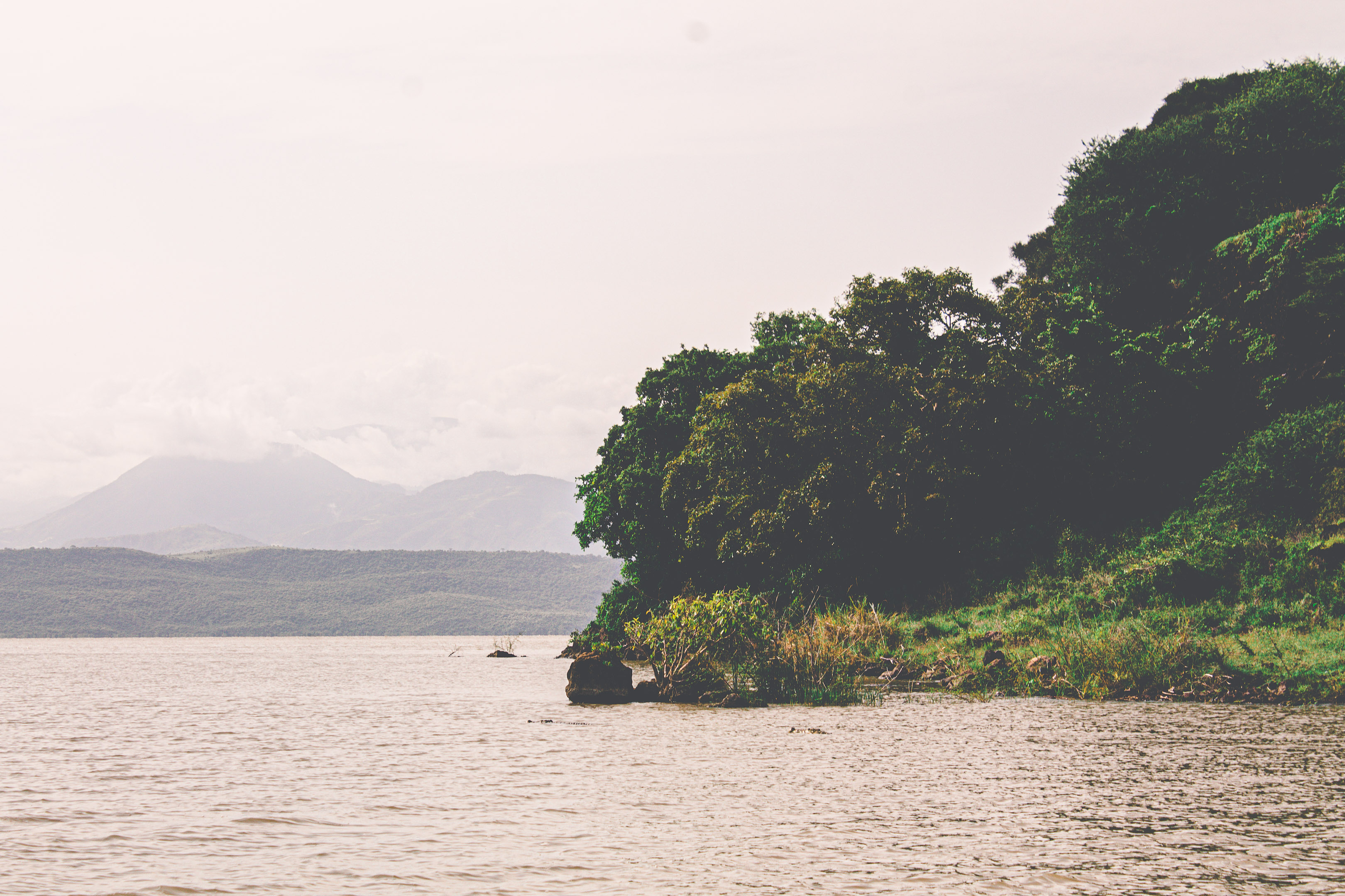
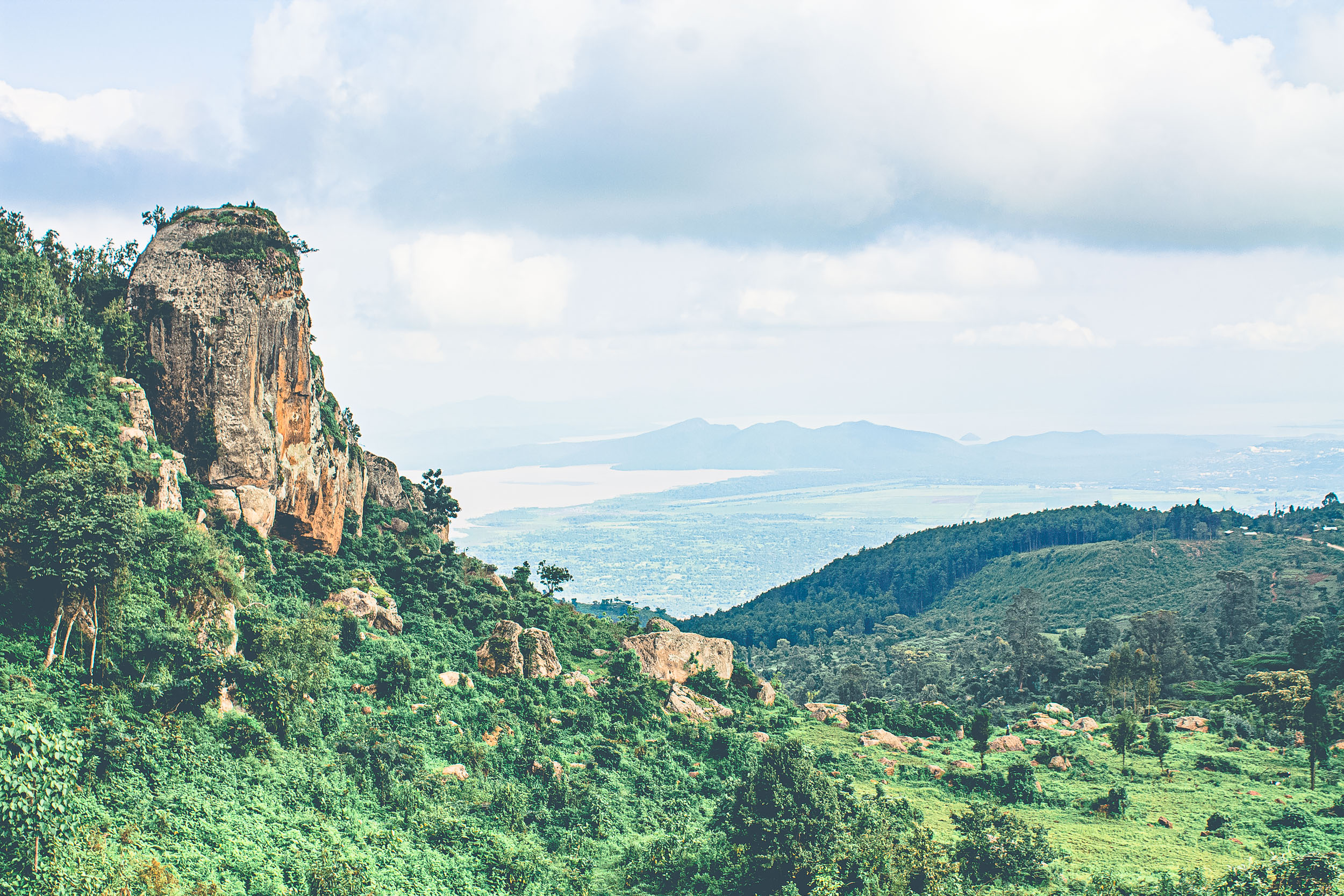
Arba Minch, which translates to "forty springs" in Amharic, is your first overnight destination. The town sits on elevated ground between two of Ethiopia's Rift Valley lakes—Lake Abaya (the largest in the Ethiopian Rift Valley) and Lake Chamo.
The setting is spectacular, with views over the lakes and the surrounding escarpment. As the sun sets, the lakes reflect shades of orange and pink, while the distant mountains create dramatic silhouettes against the sky.
Day 2: Exploring Arba Minch and Surroundings
Lake Chamo Boat Adventure
Your second day begins with one of the highlights of the entire southern Ethiopia journey: a boat trip on Lake Chamo within Nechisar National Park.
Lake Chamo is renowned for its population of massive Nile crocodiles—some of the largest in Africa. The lake's crocodile market, where dozens of crocodiles bask on the shores, is a remarkable wildlife spectacle. These prehistoric reptiles can grow up to 6 meters in length, and seeing them lined up on the muddy banks is both thrilling and slightly unnerving.
The lake is also home to hippos, which spend their days partially submerged in the water. Spotting a pod of hippos—anywhere from a few individuals to a dozen or more—is common. These massive animals are deceptively dangerous, and boat pilots maintain a respectful distance, especially when approaching mothers with calves.
Beyond the large mammals, Lake Chamo is a birdwatcher's paradise. The lake and its shores host an incredible diversity of bird species:
- African fish eagles perch in trees, their distinctive calls echoing across the water
- Pelicans glide gracefully or dive for fish
- Various heron species wade in the shallows
- Storks nest in the trees along the shore
- Kingfishers dart above the water surface
The lake supports healthy fish populations, including Nile perch, tilapia, and catfish, which sustain both the wildlife and local fishing communities.
The lake's shoreline features distinctive dead acacia trees standing in the water—victims of the lake's increasing salinity. These skeletal trees create haunting, photogenic scenes, especially when silhouetted against the morning or evening sky.
Dorze Cultural Experience
In the afternoon, you'll drive up into the highlands above Arba Minch to visit a Dorze village. This cultural experience provides fascinating insights into one of Ethiopia's many distinct ethnic groups.
The Dorze people are renowned for several cultural features:
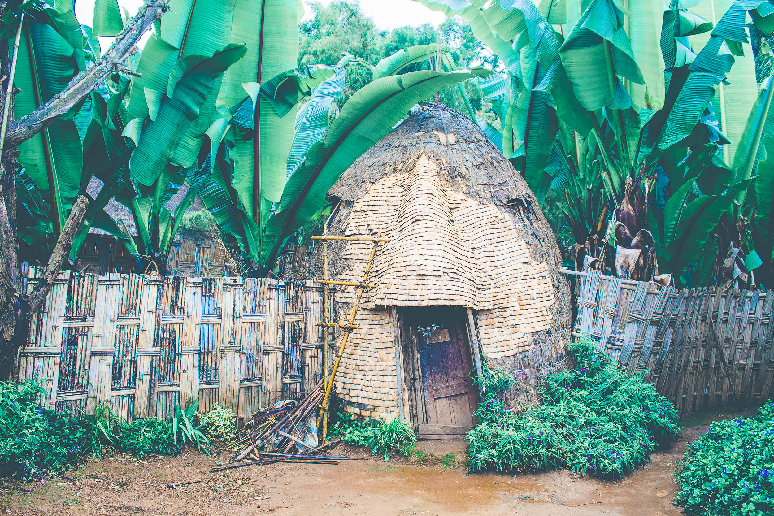
Dorze houses are among the most distinctive in Ethiopia. These tall, beehive-shaped structures are constructed from bamboo and woven enset leaves. Standing up to 12 meters tall when new, they're designed to last 60-80 years. Remarkably, if termites attack the base, the entire structure can be dismantled and rebuilt on a new foundation, though this process makes the house progressively shorter over its lifetime.
Weaving: The Dorze are expert weavers, producing beautiful cotton fabrics used for traditional clothing. During your visit, you may have the opportunity to try your hand at weaving on a traditional loom—an activity that looks far easier than it actually is and gives you immediate appreciation for this skilled craft.
Food: The Dorze's staple food is kocho, the fermented bread made from enset (false banana) roots. The preparation process is labor-intensive: the root is scraped, the pulp is fermented underground for several months, then formed into flat breads and cooked over an open fire. The result tastes mildly tangy and is traditionally served with honey and spicy sauces.
Music: Traditional Dorze music features unique string instruments, including the krar (a lyre-like instrument). Visitors often get the chance to try playing these instruments, though producing anything resembling music requires considerable practice.
Beverages: The Dorze produce a powerful homemade alcohol from fermented grains, which can reach 45-50% alcohol content. Sharing drinks is an important social custom, and visitors are often offered this potent beverage as a sign of hospitality.
Day 3: Arba Minch to Jinka
Day three is primarily a travel day, but the journey itself is part of the adventure. The road to Jinka takes you deeper into southern Ethiopia's remote regions, through changing landscapes and past rural communities whose ways of life have remained largely unchanged for generations.
The route crosses the Magu River and passes the distinctive Buska Mountains (whose name means "chain" in the local language, referring to their linked appearance). The landscape alternates between green highlands and drier lowland areas, with fields of cotton and sunflowers adding splashes of white and yellow to the scenery.
As you travel, you'll notice the temperature steadily rising. Arba Minch sits at a relatively cool altitude, but as you descend toward Jinka, temperatures can reach the mid-30s Celsius. The vegetation changes accordingly, with drought-resistant species becoming more common.
Road conditions vary on this route. Some sections are well-maintained asphalt, while others are rough dirt roads that require careful navigation. The journey provides ample opportunities for photography, so keep your camera ready for spontaneous stops to capture stunning vistas or everyday scenes of rural life.
Day 4: Jinka to Turmi via Mago National Park
Mago National Park
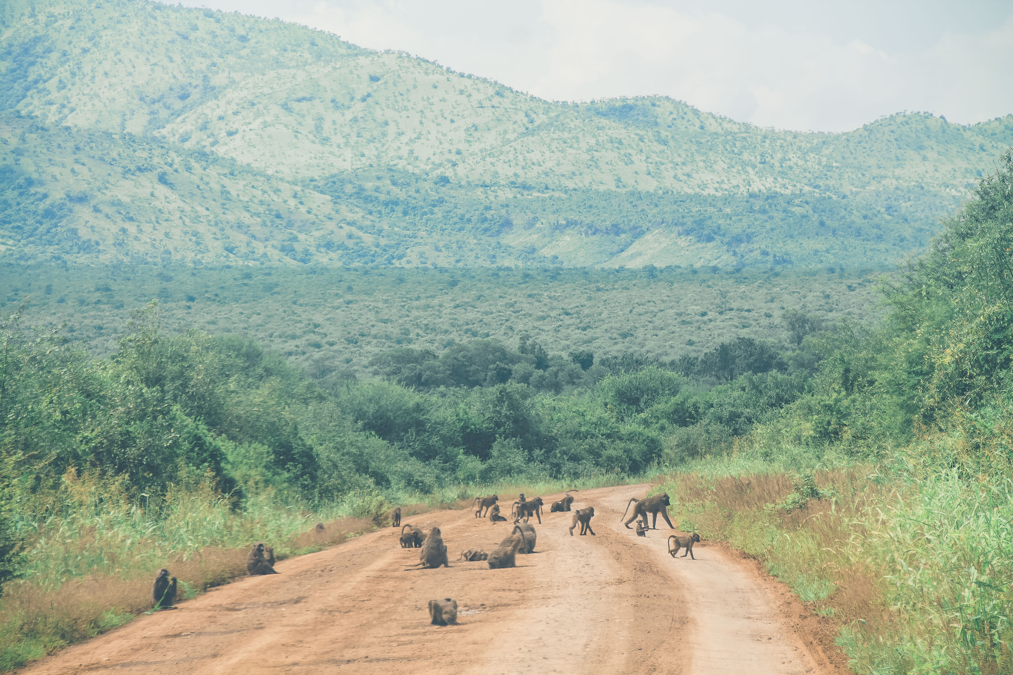
Your fourth day begins with a drive through Mago National Park, a protected area covering 2,162 square kilometers of savanna landscape. While the park once hosted significant populations of large mammals including lions, elephants, and buffalo, these populations have sadly declined due to various pressures including habitat loss and lack of conservation resources.
Today, the park is more notable as the homeland of the Mursi people than for its wildlife, though you may still spot baboons, dikdik (small antelope), and various bird species. The park's landscape is characterized by grasslands, acacia woodlands, and the winding Mago River.
Meeting the Mursi People
Within Mago National Park, you'll have the opportunity to visit a Mursi settlement. The Mursi are one of the most photographed ethnic groups in Ethiopia, primarily due to the distinctive lip plates worn by women.
The Mursi are agro-pastoralists, meaning they both keep livestock (primarily cattle) and practice small-scale agriculture. Like many pastoralist groups, they measure wealth in cattle, and these animals play a central role in their social and economic life.
The lip plate tradition is the Mursi's most famous cultural practice. When girls reach adolescence, their lower lips are pierced and gradually stretched to accommodate increasingly larger clay or wooden plates. The largest plates can be 12 centimeters in diameter or more.
Theories about the origin of this practice vary. While it was once suggested that the plates were meant to make women less attractive to slave raiders, most anthropologists now believe they serve as markers of beauty, social status, and marriageability within Mursi society.
During visits, Mursi women often paint their lip plates with intricate designs, treat their bodies with white chalk decorations, and wear traditional ornaments. The Mursi are skilled at creating crafts for sale to visitors, including the lip plates themselves, which make unique souvenirs.
It's important to approach these cultural encounters with respect and sensitivity. Always ask permission before photographing individuals, and remember that the Mursi are living their daily lives, not performing in a museum.
Journey to Turmi
After your Mursi encounter, you continue to Turmi, a small town that serves as a base for exploring the Lower Omo Valley. The landscape becomes increasingly arid as you approach Turmi, with termite mounds—some reaching several meters in height—dotting the landscape.
Day 5: Exploring the Omo Valley from Turmi
Morning Trip to Omorate
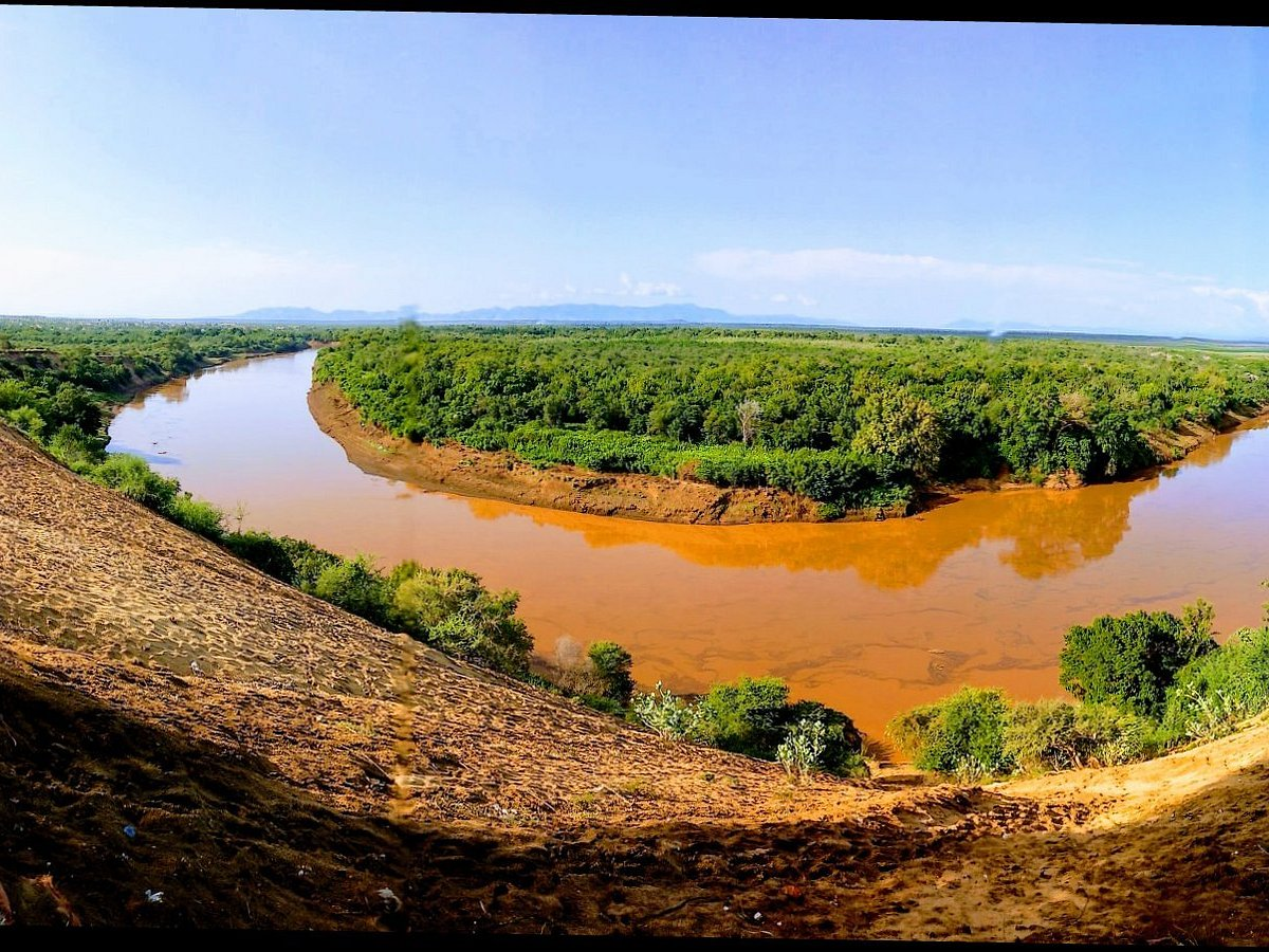
Day five takes you even further south to Omorate, a small settlement on the banks of the Omo River, very close to the Kenyan border. The journey there passes through increasingly dry landscape, with the distinctive massive termite hills becoming even more prominent.
At Omorate, you'll cross the Omo River in a traditional dugout canoe. These simple wooden boats, hollowed from single tree trunks, have been used for river crossings in this region for countless generations. The crossing itself is an adventure, with the current sometimes quite strong.
On the opposite bank live members of the Daasanech (sometimes spelled Dastenich or Dassanech) people, whose name means "people of the Omo delta." The Daasanech are another pastoralist group whose territory extends into Kenya as well as Ethiopia.
The Daasanech are known for their creative use of materials in their adornments—including bottle caps, digital watch faces, and other modern materials incorporated into traditional jewelry and headdresses. This blending of old and new creates striking visual contrasts.
Afternoon with the Hamer People
Returning to the Turmi area in the afternoon (and after escaping the intense midday heat), you'll visit a Hamer settlement. The Hamer (or Hamar) people are one of the larger ethnic groups in the Omo Valley, numbering around 50,000.
The Hamer are pastoralists who measure wealth and status through cattle ownership. Their society includes age-set systems and various coming-of-age rituals, the most famous being the bull-jumping ceremony that young men must complete to achieve adult status.
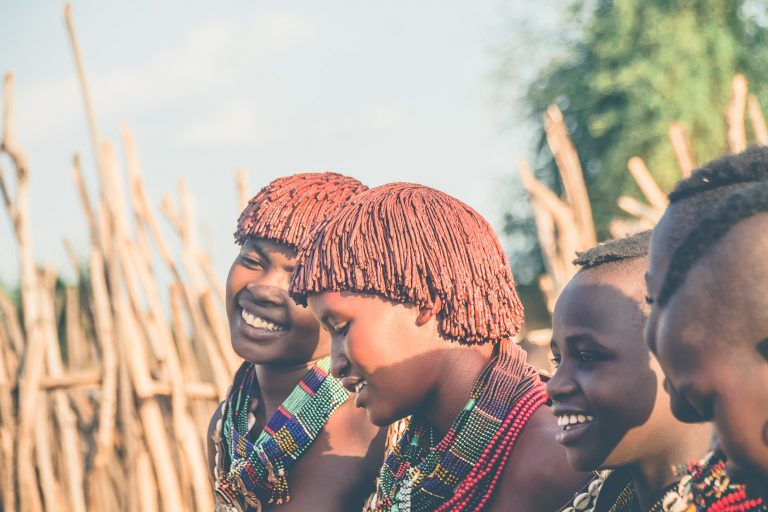
Hamer women are particularly noted for their distinctive appearance:
- Hairstyles: Women style their hair with red clay and butter, creating intricate dreadlocks adorned with beads and metal ornaments
- Clothing: Traditional dress includes goat or cattle skin skirts decorated with cowrie shells
- Jewelry: Multiple copper or iron neck rings, arm bands, and anklets
- Body decoration: Colorful beads and body painting for special occasions
Hamer women often gather to sing and dance, particularly in the late afternoon when the temperature cools. Their songs are melodic and rhythmic, often featuring call-and-response patterns. The dances involve jumping while maintaining remarkably synchronized movements.
If you visit during the right time, you might be invited to join the dance circle—an experience that's both humbling (their coordination is impressive) and joyful.
Day 6: Turmi to Konso
Transitional Landscapes
The journey from Turmi to Konso takes you back toward higher elevations and marks a transition between the predominantly pastoralist cultures of the Lower Omo Valley and the agricultural traditions of the Konso highlands.
Along the route, you'll notice churches and religious symbols becoming more prevalent. While the Omo Valley tribes maintain various traditional belief systems, the Turmi area has significant Christian Orthodox presence. You'll see people wearing crosses and women covering their heads with white scarves—markers of Orthodox Christian faith.
The Konso Cultural Landscape
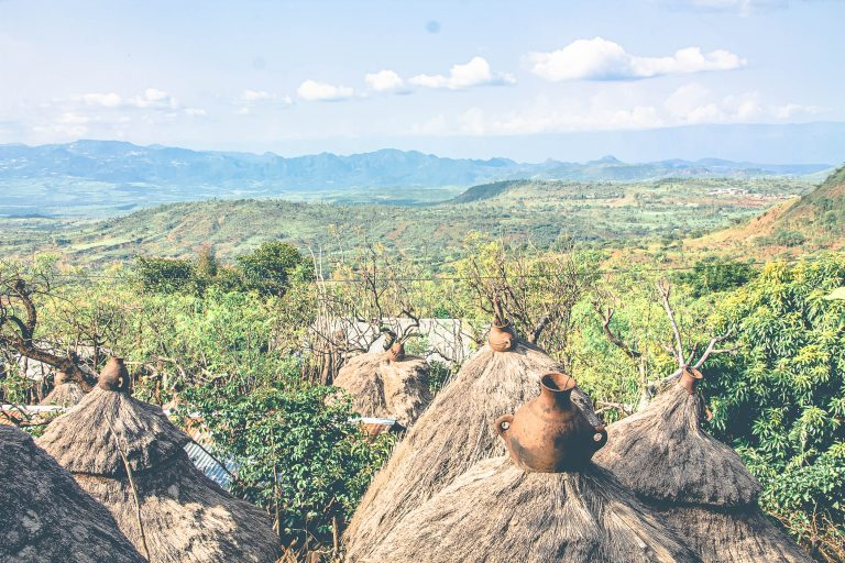
Arriving in Konso territory, you enter another UNESCO World Heritage Site—the Konso Cultural Landscape. The Konso people have created one of Africa's most sophisticated and sustainable agricultural systems, terracing steep hillsides to prevent erosion and maximize arable land.
The Konso region contains twelve traditional fortified villages, some over 400 years old. These remarkable settlements demonstrate advanced planning and social organization.
Exploring a Konso Village
A visit to a traditional Konso village (such as Gamole or Mechelo) reveals an ingenious defensive and social structure:
Circular Design: Villages are built in concentric circles, like a bullseye. As you move from the outer circles toward the center, the elevation increases and the defensive walls grow higher.
Stone Walls: Massive dry-stone walls separate each ring, built without mortar but standing for centuries. The outer walls might be 2 meters high, increasing to 4 or 5 meters in the inner circles.
Social Hierarchy: The circular design also reflects social organization, with the most respected elders and wealthiest families living in the innermost, highest circles, while younger families and those with less status occupy the outer rings.
Generation Houses: Special community buildings called "mora" serve as gathering places for age-sets and for important community discussions and ceremonies.
Wagas: These wooden memorial statues honor deceased warriors and notable individuals, standing guard over the village approaches.
Walking through a Konso village is like navigating a maze of narrow passageways, stone stairs, and gated entrances. The architecture is perfectly adapted to the terrain and climate, providing cool interiors and defensive positions.
From the highest points of these villages, the views are spectacular—on clear days, you can see back toward Arba Minch and the distant lakes.
Day 7: Konso to Hawassa
The Return Journey
Day seven marks the beginning of your return toward Addis Ababa, with an overnight stop in Hawassa. This is another long driving day, but the scenic route offers constantly changing vistas.
You'll retrace part of your earlier route through Arba Minch before taking the main road north toward Hawassa. The landscape transitions from the dry lowlands back to greener highlands as you gain elevation.
Hawassa: The Lakeside City
Hawassa (also spelled Awassa) is one of Ethiopia's more developed southern cities and serves as the capital of the Sidama Region. The city sits on the shore of Lake Hawassa, one of the Rift Valley lakes, creating a pleasant setting with a more relaxed atmosphere than many Ethiopian cities.
The lakeside promenade is Hawassa's main attraction—a paved walkway along the water where residents and visitors stroll in the evening. The promenade features:
- Benches and shaded areas for relaxing
- Vendors selling local crafts, including woven baskets and textiles
- Small restaurants and cafes
- Sunset views over the lake
- Abundant birdlife, including fish eagles and various water birds
The lake itself is relatively shallow and heavily fished. Tilapia is the main catch, supporting a significant fishing industry that employs hundreds of local people.
Day 8: Hawassa to Addis Ababa
The Fish Market
Your final day begins with an early morning visit to Hawassa's famous fish market—an experience that engages all the senses. The market operates from dawn, when the night's catches are brought ashore and sold to buyers.
The scene at the market is dynamic and photogenic:
- Fishermen arrive in simple wooden boats laden with tilapia and catfish
- Fish are displayed in neat rows for buyers to inspect
- Women prepare fish for sale, cleaning and filleting with practiced efficiency
- Marabou storks and pelicans gather, hoping for scraps
- Buyers haggle over prices in Amharic and local languages
- Vendors prepare fish soup, grilled fish, and traditional sauces
The market represents a traditional fishing economy that has sustained communities around Lake Hawassa for generations. While tourism has become important to the city's economy, fishing remains a vital livelihood, often passed down through families.
The Final Stretch
After the fish market visit, you begin the final leg of your journey back to Addis Ababa. The road is well-maintained, and the drive takes approximately 4-5 hours depending on traffic.
As you approach the capital, you'll notice the landscape transitioning back to the cooler highland environment of central Ethiopia. The journey comes full circle, returning you to where you started eight days earlier—though now with a much deeper appreciation for Ethiopia's incredible diversity.
Practical Considerations for the Journey
Transportation
Southern Ethiopia's road conditions vary significantly. While main routes are increasingly paved, many roads—especially in the Omo Valley—remain rough dirt tracks. A sturdy 4x4 vehicle is essential, and experienced drivers who know the routes make a significant difference.
The roads are shared with herds of cattle and goats, donkey carts, and pedestrians. Driving requires constant vigilance and patience. In some areas, you may encounter unofficial roadblocks or requests for payments, which an experienced local driver can navigate more effectively than foreign visitors attempting to drive themselves.
Climate and What to Bring
The climate varies dramatically across the route:
Highlands (Addis Ababa, Konso): Cool temperatures, especially at night. Bring warm layers.
Midlands (Arba Minch): Moderate temperatures, generally comfortable.
Lowlands (Turmi, Omorate, Omo Valley): Extremely hot, often exceeding 40°C. Bring sun protection, light clothing, and plenty of water.
Essential items include:
- Sunscreen and sun hat
- Sunglasses
- Light, breathable clothing for hot areas
- Warm layers for cool evenings in highlands
- Good walking shoes
- Camera and extra batteries
- Water bottle
- Basic first aid kit
Cultural Sensitivity
When visiting tribal communities:
- Always ask permission before photographing people
- Dress modestly, respecting local customs
- Learn a few words in Amharic as a sign of respect
- Be patient and respectful of different customs and timelines
- Understand that some communities expect payment for photographs
- Don't make promises you can't keep
- Avoid judging practices by your own cultural standards
Health and Safety
- Bring antimalarial medication—the lowland areas are malarial
- Stay hydrated, especially in hot areas
- Eat at established restaurants when possible
- Bring hand sanitizer and use it regularly
- Have comprehensive travel insurance
- Carry cash—card acceptance is very limited outside major cities
Best Time to Visit
The dry season (October to March) is generally the best time for this journey:
- Roads are in better condition
- Wildlife viewing is better at water sources
- Photography conditions are ideal with clear skies
- Temperatures are somewhat cooler (though still hot in lowlands)
The wet season (June to September) makes some roads difficult or impassable, though the landscapes are greener.
The Cultural Significance
This journey through southern Ethiopia offers far more than beautiful scenery—it provides insights into some of Africa's most resilient and distinctive cultures. The ethnic groups you'll encounter have maintained their traditions, languages, and ways of life despite enormous pressures from modernization, climate change, and globalization.
Each group has developed unique adaptations to their environment:
- The Konso's terraced agriculture and fortified villages
- The Dorze's remarkable architecture and weaving traditions
- The Mursi, Hamer, and Daasanech's pastoralist lifestyles in harsh conditions
- Various groups' intricate body modifications and adornments
Understanding and respecting these cultural differences enriches the travel experience and helps support the preservation of these unique traditions.
Conclusion
An 8-day road trip through southern Ethiopia is a journey unlike any other in Africa. From ancient standing stones to fortified hilltop villages, from crocodile-filled lakes to remote pastoral communities, the diversity of experiences is extraordinary.
The journey challenges you—with long drives on rough roads, extreme temperatures, and encounters with ways of life very different from most visitors' own experiences. But it also rewards you with some of the most authentic cultural encounters available anywhere in Africa, landscapes of stunning beauty, and memories that will last a lifetime.
Southern Ethiopia remains relatively undiscovered compared to the northern historical circuit, giving travelers a sense of exploration and discovery. As you complete this journey, you'll understand why Ethiopia is called "the land of origins"—not just because of its paleoanthropological significance, but because it shows us something fundamental about human cultural diversity and resilience.
Whether it's sitting among a Hamer dance circle, watching massive crocodiles bask in Lake Chamo, exploring a 900-year-old Konso village, or sharing drinks with Dorze weavers, each experience contributes to a profound appreciation for Ethiopia's remarkable cultural tapestry.
This is not a luxury vacation or an easy trip—it's an adventure that requires flexibility, patience, and openness. But for those willing to embrace the challenges, southern Ethiopia offers one of the world's great travel experiences.
Frequently Asked Questions
1. How many ethnic groups will I encounter on this journey? You'll visit communities from at least 5-6 distinct ethnic groups including the Dorze, Mursi, Hamer, Daasanech, and Konso, each with unique languages, customs, and traditions.
2. Is it safe to travel in southern Ethiopia? Generally yes, though you should travel with experienced guides and drivers who know the region. Some areas require armed scouts for protection, which is arranged through official channels.
3. What's the best time of year for this trip? The dry season from October to March offers the best road conditions and weather, though temperatures in the lowlands can be extremely hot year-round.
4. Do I need any special vaccinations? Consult your doctor, but yellow fever vaccination is recommended, and antimalarial medication is essential for lowland areas. Routine vaccinations should be up to date.
5. Can I do this trip independently? While possible, it's much easier and safer with an experienced driver and guide. Road conditions, language barriers, and cultural protocols make independent travel quite challenging.
6. What about accommodation? Accommodation ranges from basic guesthouses to more comfortable hotels. Don't expect luxury—clean and functional is the standard, especially in remote areas like Turmi and Jinka.
7. How much cash should I bring? Bring enough cash for the entire trip as ATMs are rare outside major cities and card payments are almost never accepted. US dollars can be exchanged in Addis Ababa.
8. What photography equipment should I bring? A good camera with both wide-angle and telephoto lenses is ideal. Bring extra batteries and memory cards, as charging opportunities may be limited.
This article was originally published on January 22, 2026.